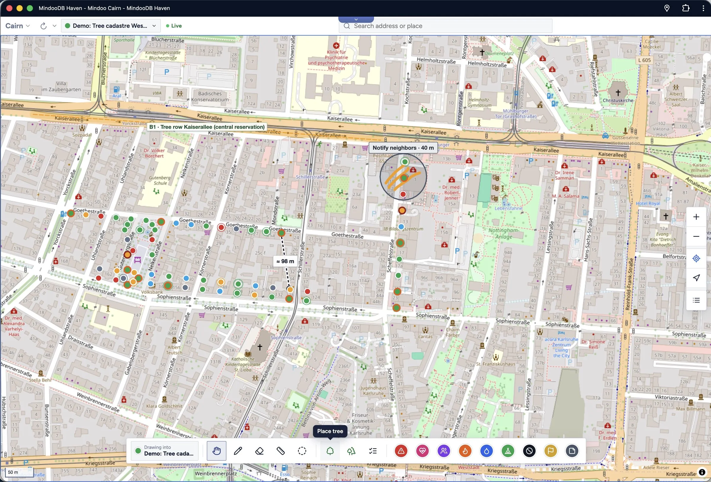
Tree inventory on the map: trees coloured by inspection status, a tree row as a stand, sketches, areas and distance measurements
Shared field map

The map that keeps working when the network doesn't.

Mindoo Cairn puts pins, photos, sketches and areas on one shared map for your whole team. Every device keeps its own copy, works offline and merges its changes as soon as it meets the others again.

Offline maps Peer-to-peer sync End-to-end encrypted
Anywhere on the planet

From relief teams in remote crisis areas …

Field teams keep mapping without mobile coverage. When two devices meet, they exchange what they know, directly and without a server.

Down to a single tree

… to the oak in front of the town hall.

Zoom in from the planet to the street: every tree, hydrant and playground can carry its own record, inspections and photos.

One map. Every detail. Always in sync.

  • Tree inventory
  • Crisis maps
  • Playground checks
  • Hydrant inspections
  • Nest boxes
  • Street festivals
  • Scavenger hunts
  • Poster print
  • Time travel
One map, many missions

Start a workbook for the job at hand

A workbook is a layer on the map with its own purpose, its own colour and its own readers. Pick a kind when you create it, and Cairn brings the forms, lists and reports that job needs.

01
Tree inventory

Every tree with its record, inspections and measures

Map trees and whole stands after the FLL guideline. Trees are coloured by inspection status, the list filters what is due, overdue or never inspected, and measures go through a four-eyes approval. Inspection records and lists come out as PDF.

  • Master data, defects and next inspection date per tree
  • Measures from open to done to approved
  • Built for municipalities and for private owners
02
Crisis response

A shared situation map, even without infrastructure

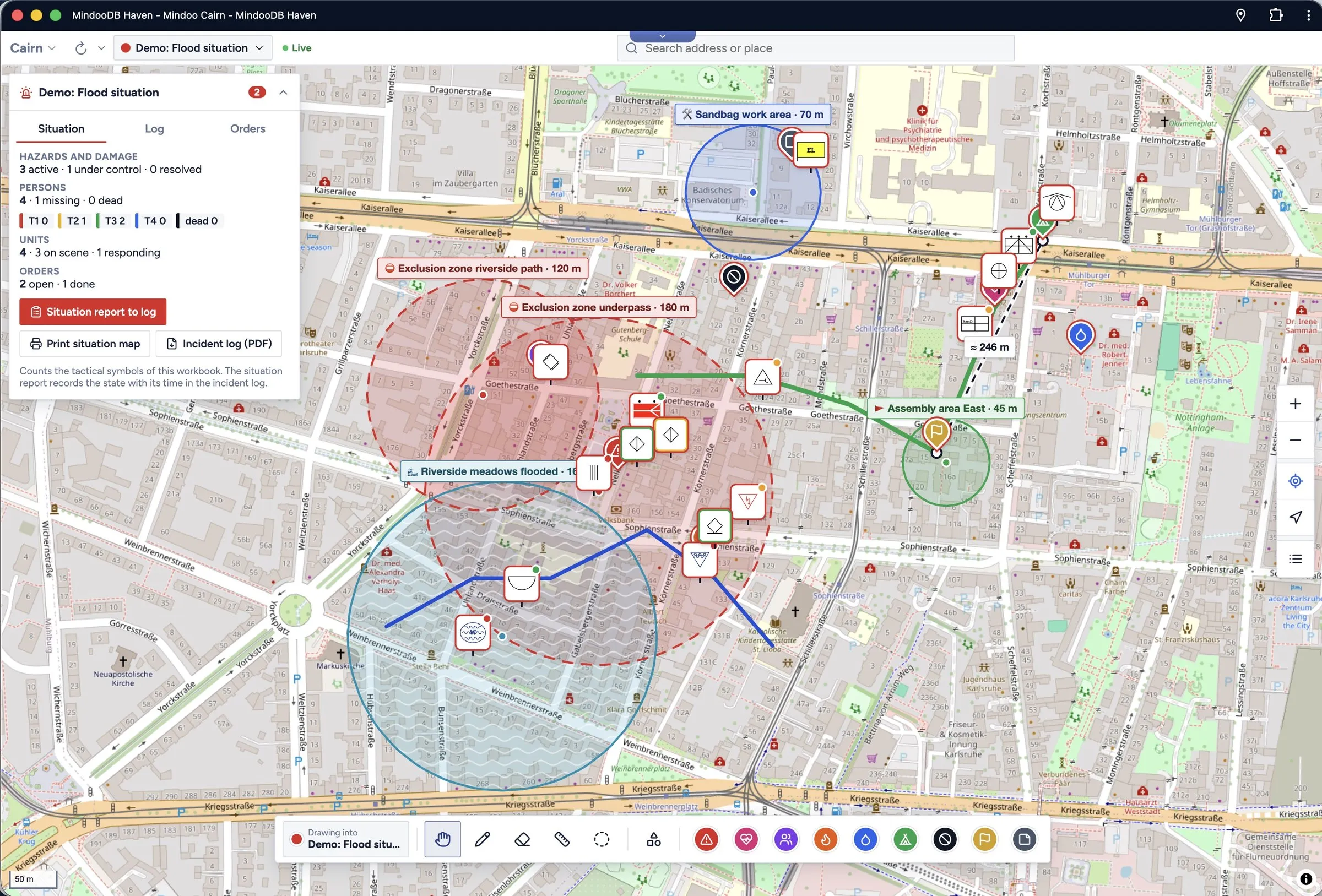
In crisis areas around the world, relief teams record what they see with tactical symbols, status, counts and triage categories. Peer-to-peer sync keeps everyone in step when there is no server and no mobile network — devices merge their changes the moment they meet.

  • Exclusion, danger, work and flood areas
  • Incident log, orders and situation reports as PDF
  • Sync through a server or directly between devices
03
Asset inspection

Playgrounds, hydrants, nest boxes — inspected on time

Set up an inspection workbook for playground equipment after EN 1176-7, fire hydrants, nest boxes or any other asset on the map. Checklists, intervals and measures make sure nothing is forgotten, and QR labels mark every object on site.

  • Checklists and inspection intervals per profile
  • PDF records and QR labels for every object
  • Due dates visible right on the map
04
Event planning

Plan the street festival on the map everyone sees

Meeting points, stands, first aid, routes and closed streets: sketch the plan together, add a legend and print it as a poster. Every helper has the same picture on their phone on the day.

  • Routes, areas and labelled meeting points
  • Legend for every layer
  • Wall-sized poster print and PDF
05
Scavenger hunt

Turn the city into a game

Plan stations with riddles, location codes and mini games, test them and publish the hunt encrypted. Players only unlock the next clue at the right place — and a comic intro, a ranking and a finale with fanfare make it an adventure.

  • Riddles, location codes and QR signs
  • Mini games with camera, microphone and motion
  • Team play with shared secrets
Mark what matters

Draw on the map with pen, touch or mouse

Circle the damaged section, sketch the escape route, measure the distance to the next hydrant. Whatever you mark lands in the workbook as its own object, so several people can draw at the same time without getting in each other's way.

Illustration
Time travel

Compare any two points in time

MindooDB stores every change append-only — nothing is overwritten. So Cairn can show a workbook as it was on any earlier date and put it next to today: side by side, or with a slider you drag across the map.

  • See what changed after a storm, an inspection round or a long shift
  • Every change stays in the history, with author and time
  • Works for every kind of workbook
Monday, 09:00
Wednesday, 18:00

Illustration of the compare view: the flood area has grown, two new shelters and an access route were added.

Sync & offline

Always up to date — with or without a network

Every device holds the full, encrypted workbook. You work at full speed offline, and changes merge without conflicts once devices are back in touch.

Sync server +1 +2 +1
Online: changes travel through the sync server in seconds.

Offline maps

Download map areas ahead of time, or use the offline planet map. Map material and workbooks stay usable in the cellar, in the forest and in the disaster zone.

Peer-to-peer

When there is no server within reach, devices sync directly with each other and carry updates from team to team.

Conflict-free merging

Each pin, stroke and measurement is its own document, so parallel work merges as new objects instead of fighting over one drawing.

Encryption

Who may read a workbook is your decision

Everything is encrypted on the device before it is stored or sent. Even the operator of the sync server only ever sees ciphertext.

Shared key

Everyone who holds the workbook's key can read it — ideal for a team, a department or an event crew.

Selected readers

Only the people you name can decrypt the workbook. Perfect for sensitive situation maps or private property.

Hydrant H-117 · valve stiff · repair by Friday

Smartphone, tablet, desktop

In the field, in the vehicle, in the office

Cairn runs wherever MindooDB Haven runs: on the phone in your pocket, on the tablet in the command vehicle and on the big screen in the office. Thanks to sync, all of them always show the same map.

Tree inventory on the map: trees coloured by inspection status, a tree row as a stand, sketches, areas and distance measurements
Desktop
A crisis situation map with exclusion and flood areas, tactical symbols and the situation overview
Tablet
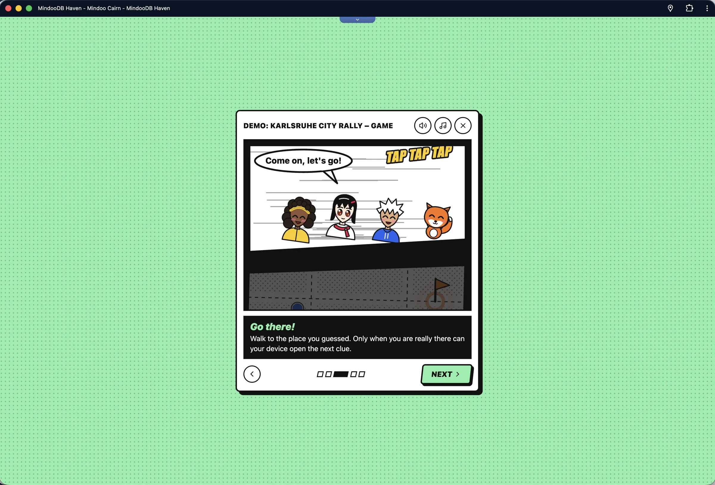
Scavenger hunt comic intro: go there
Smartphone
Play outside

Scavenger hunts with a comic intro and mini games

Cairn is not only for serious work. Plan a city rally for a school class, a birthday or a team event: players follow encrypted clues, solve mini games with camera, microphone and motion sensors and race for the podium.

In the game

Players see their trail, the next clue and their team on the map. A balloon-popping mini game is one of many challenges a station can hold.

Map styles

OpenStreetMap, vector maps and 3D buildings

Switch between classic OpenStreetMap tiles, sharp vector maps and a 3D view with buildings. Tilt and rotate the map with two fingers, and tap any point of interest to see what OpenStreetMap knows about it.

  • Raster and vector map styles, light and dark
  • 3D buildings with tilt and rotation
  • Address search and OpenStreetMap details
Paper still matters

Posters, records and reports

Print the map as a wall-sized poster for the briefing, hand out inspection records as PDF, or send a situation report to the command staff.

Poster print

Any section of the map, tiled across as many sheets as you like.

PDF records

Inspection records with photos, tree lists and measure lists.

Situation reports

Incident log, orders and the current situation as PDF.

Workbook kinds

General map, crisis situation, tree inventory, asset inspection and scavenger hunt.

Built on MindooDB Haven

Your data, your devices, your keys

Cairn is an app for MindooDB Haven, the local-first platform for end-to-end encrypted team apps. Install it from the Haven App Store next to your other apps and share workbooks with the people you already work with.

01

Local-first

Data lives on your devices first. The app opens instantly and never waits for a server.

02

End-to-end encrypted

Keys stay with you. Servers store and forward ciphertext only.

03

Append-only history

Every change is kept, which is what makes time travel possible.

04

Eight languages

German, English, Spanish, French, Italian, Norwegian, Dutch and Polish.

FAQ

Frequently asked questions

Do I need an internet connection to use Cairn?

No. Workbooks are stored on your device, and map areas can be kept offline. You need a connection — or another device nearby — only to exchange changes with your team.

How does peer-to-peer sync work?

Two devices that can reach each other exchange the changes the other one is missing. Because every object is its own document and MindooDB merges without conflicts, the result is the same no matter in which order devices meet.

Who can read my workbooks?

Only the people you allow: either everyone who holds the workbook's shared key, or a list of selected users. Data is encrypted on the device, so the sync server cannot read it.

Which devices are supported?

Smartphones, tablets and desktop computers — in the browser and in the Haven apps. You can draw with a pen, with your finger or with the mouse.

Can I see what a map looked like last week?

Yes. Time travel opens a workbook at any earlier point in time and compares it with another one, side by side or with a slider.

Where does the map data come from?

From OpenStreetMap and its contributors, as raster tiles or vector maps. Points of interest can show the OpenStreetMap details behind them.

Put your next mission on the map

Open MindooDB Haven, install Mindoo Cairn from the App Store and create your first workbook — or start with the demo data.

Cairn itself is free. Sync through MindooDB Cloud starts at €7.99 per user per month — see pricing.